ckanext-spatial 是一個 ckan 的延伸套件 (extension),提供地理資訊相關功能。
詳細介紹可以參考 ckanext-spatial 的官方 github 。
外掛主要功能簡介
spatial_metadata
建立地理空間資訊之索引。
Spatial Search Widget
按地圖搜尋資料集 "spatial" 欄位的地理空間資訊,僅支援 solr 3.1+。安裝完成後,即可在資料集清單顯示頁面的左下角看到 "Filter by location" 的區塊,此區塊並可放大後,依照使用者選取的地理區域篩選出符合的資料集。
欲使用此功能,請在 ckan.plugins 加入 spatial_metadata 與 spatial_query。
Dataset Extent Map
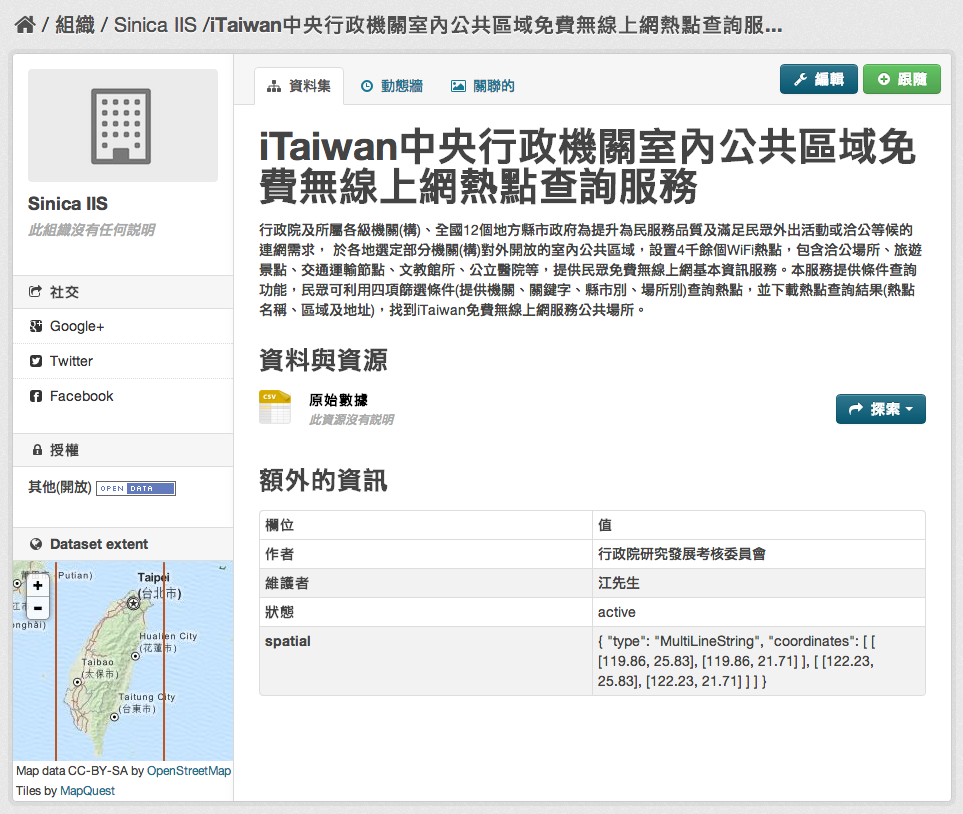
以地圖顯示資料集 "spatial" 欄位所述之地理空間資訊 (僅支援 geojson 格式)。如下圖所示,在「額外的資訊」中填寫的 spatial geojson 資訊,將顯示在左下角的 Dataset extent 中。
欲使用此功能,請在 ckan.plugins 加入 spatial_metadata。

WMS Preview
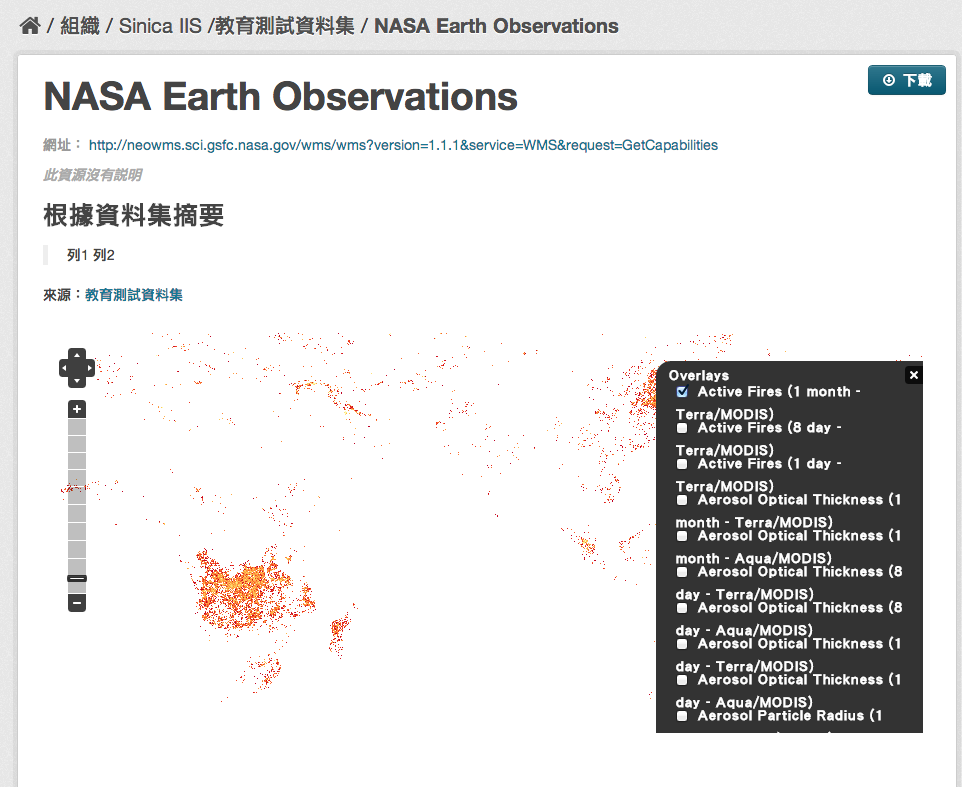
此功能可以地圖方式呈現 wms 服務所涵括的地理範圍 (GetCapabilities),並可切換圖層。
欲使用此功能,請在 ckan.plugins 加入 wms_preview。
以 NASA Earth Observations 為例:

GeoJSON Preview
以地圖檢視 GeoJSON 檔案(ckan 內建之 preview 僅支援以樹狀結構顯示 json 格式文件)。支援 geojson 與 gjosn 兩種檔案格式名稱定義。 欲使用此功能,請在 ckan.plugins 加入 geojson_preview 與 resource_proxy。
CSW Server
提供 CSW 服務介面(研究中)。
Spatial Harvesters
提供地理空間相關的 harvesters,可以將 CSW, WAF, spatial metadata document 等資料目錄來源的後設資料擷取下來並匯入 ckan 之中。須注意的是,資料本身仍然位於原資料目錄之網站。此 harvester 係實作 ckanext-harvest 套件之 harvester interface。
欲使用此功能,請安裝 ckanext-harvest 外掛 並在 ckan.plugins 加入 csw_harvester, doc_harvester 與 waf_harvester。
Note
ckanext-spatial 提供的 havester 現階段 (0.2) 並不穩定,匯入大量資料很緩慢(實測 11,400 筆左右需時 3 小時),且容易因 source 缺少某些欄位值或 source 資料格式與 harvester(及其相依的 python library)不符而引發 python exception。另外於 import stage 時若持續發生 error,即使在 conf 檔案設定忽略,也會發生卡死的情況。
並且,只要一卡死,harvest 工作就不算完成,要重新開始僅能清除所有已下載下來的 metadata,再執行一次。
使用步驟說明:
新增 harvest source:
使用瀏覽器開啟 SITE_URL/harvest,選取右上之 "Add Harvest source",依照畫面輸入 source 網址及選取 source 類別。 .. note:
若您有成功安裝 ckanext-spatial 套件並啟用上述三個 plugins,應該可以看到 "CKAN, CSW Server, Web Accessible Folder (WAF), Single spatial metadata document" 四種 source 類別
執行 harvest 工作(手動):
進入 virtualenv,執行 gather 與 fetch handler:
(pyenv) $ paster --plugin=ckanext-harvest harvester gather_consumer -c /etc/ckan/default/production.ini
(pyenv) $ paster --plugin=ckanext-harvest harvester fetch_consumer -c /etc/ckan/default/production.ini
Note
請勿關閉這兩個 handler
使用瀏覽器開啟 SITE_URL/harvest,進入剛才建立的 harvest source,選擇右上的「管理者」按鈕,在接下來的頁面選取 "Reharvest",將此 harvest 工作送入排程。
最後進入 virtualenv,執行 run handler:
(pyenv) $ paster --plugin=ckanext-harvest harvester run -c /etc/ckan/default/production.ini
即會立即開始執行剛才加入的工作排程。
Note
手動執行時 harvest 工作並不會自行停止,因為上述 paster harvester run 指令同時也用來確認 harvest 工作是否完成。因此若您確定 harvest 工作已經完成(或已發生錯誤),可以再次執行 run 指令,即可透過下述 d. 的方式檢視此次工作的結果
執行 harvest 工作(自動):
確認 harvest 工作的執行狀況:
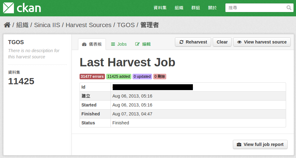
我們可以在網頁介面,harvest source 的「管理者」頁面確認 harvest 工作的執行狀況,包括錯誤、新增、更新、完成的資料集數目,如下圖所示:

系統需求
- Python (2 or 3) 安裝於 virtualenv
- ckan (>=1.8)
- solr (>=3.1)
- ckanext-harvest (ckan 延伸套件):外掛 spatial-harvesters 需要
Note
- 若依照本文件的教學安裝 ckan,你應該已經擁有上述前三套套件
- Dataset Extent Map 與 Spatial Search Widget 兩個 snippets 需要 ckan>=2.0
安裝
安裝 ckanext-spatial 套件:
(pyenv) $ pip install -e git+https://github.com/okfn/ckanext-spatial.git@release-v2.0#egg=ckanext-spatial
Note
release-v2.0 請自行依 ckan 版本替換之
安裝其他需要的 Python 套件:
(pyenv) $ pip install -r pip-requirements.txt
安裝 PostGIS:
請直接參考 官方的安裝說明 。
修改 ckan 設定檔:
打開 ckan 設定檔(一般位於 /etc/ckan/default/),並加入:
ckanext.spatial.search_backend = solr
並修改 ckan.plugins 參數,增加需要的外掛(參見下文介紹)。
修改 solr schema:
打開 solr schema(一般位於 /usr/share/solr/collection1/conf/solrconfig.xml),找到 <fields> 區段,加上:
<fields>
    <!-- ... -->
    <field name="bbox_area" type="float" indexed="true" stored="true" />
    <field name="maxx" type="float" indexed="true" stored="true" />
    <field name="maxy" type="float" indexed="true" stored="true" />
    <field name="minx" type="float" indexed="true" stored="true" />
    <field name="miny" type="float" indexed="true" stored="true" />
</fields>
新增 Spatial Search Widget:
打開 cakn source 目錄下的 ./ckan/templates/package/search.html,在 {% block secondary_content %} 段落中加入
{% snippet "spatial/snippets/spatial_query.html" %}
新增 Dataset Extent Map (widget):
打開 cakn source 目錄下的 ./ckan/templates/package/read.html,在最後加入
{% block secondary_content %}
  {{ super() }}

  {% set dataset_extent = h.get_pkg_dict_extra(c.pkg_dict, 'spatial', '') %}
  {% if dataset_extent %}
    {% snippet "spatial/snippets/dataset_map_sidebar.html", extent=dataset_extent %}
  {% endif %}

{% endblock %}